Electronic orientation table
Collaboration with Imagine team of LIRIS Laboratory in Lyon
Our current works consist in creating and exploiting computer vision algorithms in order to provide augmented reality frameworks.
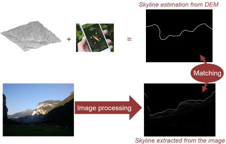
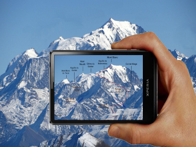
For example, the idea of this work is to create a smartphone application that provides as much information as possible to the people looking at a mountain landscape. The idea in that precise context consists in visualizing the landscape with the smartphone camera and the desired information will be displayed on the screen thanks to augmented reality tools.
The main problem for such application is to match the knowledge we have about the landscape with the images that are displayed on the screen as data given by the smartphone are usually inaccurate. Our solution consists in extracting a probability map of skyline in the image acquired by the smartphone camera and then, to match these data with the 3D data available from the Digital Elevation Model.
Our contributions are threefold:
- We fully exploit the 3D color information of the pixels by learning a color metric that helps in discriminating skyline edges from non-skyline edges.
- We propose a fast matching between the probability map and the 3D data available from the DEM, laying the foundations for collaborative models.
- We created a new tagged dataset with ground-truth so that the accuracy of the different approaches can be assessed and compared.