Synthetic Aperture Radar (SAR) image restoration
SAR imagery is a widely used technique for Earth obervation. It offers complementary information to the more common optical imaging. Among its distinctive features, one may cite its all-weather and day-and-night imaging capabilities, the interferometric configurations that give access to 3-D reconstructions for digital elevation models and displacement estimation, or the polarimetric and tomographic modes that give access to estimates of the biomass in forested areas.
Coherent combination of several radar echoes within each resolution cell results in interferences and the well-known speckle phenomenon. Due to speckle, regions with homogeneous radar properties display strong fluctuations in SAR images. Direct estimation of the reflectivity, the interferometric phase or polarimetric properties is unusable given its prohibitively large variance. Speckle reduction is thus a longstanding topic in SAR imagery.
Through a long-standing collaboration with the Signal and Image Processing department of Telecom Paristech, we have developped several methods to reduce speckle and reconstruct interferometric phase, polarimetric or height information.
SAR image restoration is the subject of collaborations with the Institut Mathématique de Bordeaux, ENS Cachan, CNES, ONERA, IETR, DLR (Germany), UCLA (USA), and Univ. Naples (Italy).
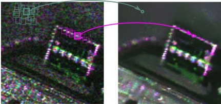
By combining only pixels with a similar surrounding context, patch-based methods can produce a very effective reduction of speckle while preserving the resolution. In this image in false colors, color encodes polarimetric information. The original speckle-corrupted image is on the left, the restored image is on the right.
Deledalle, C. A., Denis, L., Tupin, F., Reigber, A., & Jäger, M. (2015). NL-SAR: A unified nonlocal framework for resolution-preserving (Pol)(In) SAR denoising. IEEE Transactions on Geoscience and Remote Sensing, 53(4), 2021-2038.